I had filed an instrument flight plan the night before. After making a quick check of the weather on the route and the updated forecast, we were ready to head out. As expected, the engine started easily. I set the altimeter so that the airport's elevation appeared. With a traditional altimeter, the barometer setting is dialed in the "Kohlsman" window. I wonder what they would call the window on this new glass panel aircraft...it's just a box on a computer screen.
Anyway, the winds were light but favored runway 32, so I didn't have far to taxi. There was a skyhawk just ahead of me who announced on the CTAF that he would taxi across the runway for runup. I taxied short of the runway on the near side and angled the prop wash away from the parked aircraft. I set the radios and entered the Lakeland VOR in the GPS as a direct-to. This was my first point on my flight plan and I did not expect any problem getting a clearance once I was airborn. I quickly ran through the checklist and satisfied that all was well, I announced that I would be taking runway 32. The other Skyhawk was still completing his runup while a third airplane had just pulled from his parking spot. Looked like the morning was going to be busy.
Holding the brakes, I ran the engine to full power noting that the RPM had reached 2,400. I released the brakes and we were rolling. The speed came up quickly and I nosed her into the air adjusting my attitude to maintain 74 knots. Since there is a neighborhood in the flight path, I maintained a straight-ahead path until I reached 1000' then I made my left turns which put me on an almost direct path to LAL. I leveled off at 2000' and established a heading of 130 - direct to LAL. After engaging the autopilot and setting it to follow the NAV and maintain altitude, I contacted Tampa Approach and requested my instrument clearance to F45. Approach was busy, so he gave me a transponder code and told me to stand by while he retrieved my clearance.
The controller told me that he had my clearance and asked that I tell him when I was ready to copy. I immediately replied that I was ready.
"Cleared via radar vectors to HALLR, Hotel, alpha, lima, lima, romeo; then direct ULLMN, uniform-lima-lima-mike-november; then direct Palm Beach; then direct Foxtrot-4-5." came the clearance.
I repeated the clearance and was told to fly heading 130 and climb to 5000. I switched the autopilot to heading mode and began my climb to 5000. I also entered HALLR as a direct-to in the GPS and began to enter the rest of the plan.
We passed by the Lakeland Linder airport where I shot these photos out the window.

Prior to reaching HALLR, the controller handed me off to Miami and told me I would receive my on course clearance from the Miami controller. About 10 minutes after contacting Miami center, I asked the controller if I could get my on course clearance. The controller said that he thought the prior controller cleared me and apologized. He cleared me direct to ULLMN. I tried hard to find ULLMN on my instrument chart, but it simply wasn't there. It turns out that it REALLY isn't on the L19 chart. I don't know why. Fortunately, the GPS showed me exactly where it was - in the middle of lake Okeechobee.

I updated the GPS and adjusted my course slightly to head straight for ULLMN. I was a bit nervous about flying over the big lake. If the engine died, we would be stretching our glide distance to the limit in order to make it to shore. A forced landing in the middle of the lake would satisfy a few alligators' hunger, and surviving would be a challenge if the water was deep enough for the plane to sink. Therefore, I monitored every instrument very carefully to ensure that nothing was about to go wrong. We had clear skies ahead, so weather would not be a problem. I kept a close eye on the GPS which provided an indication of the relative wind. We were getting between 9 and 11 knots of wind from our front left quarter. Knowing this, I reasoned if we were less than 2/3rds of the way across the lake, an engine problem would result in my banking to the right immediately while pitching for 69 knots to make a 120 degree turn to put the wind behind me. This would maximize our distance covered while in best glide configuration. Fortunately, we didn't need to make use of these plans as we made it across the lake safely. I took a couple of shots of the lake, but it just looks like a bunch of blue from the middle. The shots I took as we crossed the west boundary are much more interesting - here's one:
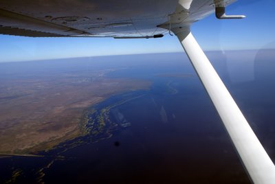 The dark spot near the bottom of the shot is a mote on my camera lens.
Near the eastern end of the lake, ATC instructed me to descend to 3000' and cleared me direct F45. With the airport in sight, I canceled IFR and made a VFR approach to runway 31 which was being used by several other planes. I came in a bit hot and landed longer than I like to, but there would have been little point in landing short as there were no turnoffs near by.
This was a great day for flying and for seeing parts of Florida that I had not seen from the air in the past. I even got a shot of the Sebring airport where they have the 12 hour endurance race every year. Here it is:

So, that gives me another 1.6 hours of cross-country flying with a measly 0.2 hours of actual instrument time. All in all, an outstanding flight.
David West


No comments:
Post a Comment